Friday, 29 October 2021

In the town of Viana do Castelo, in the Norte Region of Portugal

 "Life is what we make of it. Travel is the traveler. What we see isn't what we see, but what we are." -- Fernando Pessoa

==================================================================

() The town of Viana do Castelo, seat of the district of Viana do Castelo, is located on the Portuguese Way, an alternative path of the Camino de Santiago, at the mouth of the Lima River. The jewel of the Costa Verde (Green Coast), Viana do Castelo is blessed with an appealing medieval center, an attractive riverfront, and lovely beaches -- just outside the city. The old quarter showcases leafy 19th-century boulevards and narrow lanes crowded with Manueline manors and rococo palaces, all dramatically presided over by the pearly white, neo-Byzantine Santa Luzia church (depicted here) on the hilltop high above town. The town’s setting, by the Rio Lima estuary, makes Viana a great base for exploring the lower Lima valley. One of the most beautiful sanctuaries in Portugal, and the most charismatic symbol of the region, the Sanctuary of Santa Luzia attracts many tourists who traverse its beautiful interior, until they reach the top and can marvel at the spectacular views over the landscape below. Indeed, there are two good reasons they visit Viana’s 228-meter eucalyptus-clad hill, known as Monte de Santa Luzia. One is the wondrous view down the coast and up the Lima valley. The other is the fabulous, neo-Byzantine Templo do Sagrado Coração de Jesus. where they seem to feel just a little bit closer to heaven by climbing to the zimbório (lantern tower) atop its dome, via a lift, followed by a narrow stairway.


At Lake Como, in Lombardy, Italy

 “A lake carries you into recesses of feeling, otherwise impenetrable.”

-- William Wordsworth
==================================================================

(in Lombardy, Italy) Lake Como, also known as Lario, is the third largest of the Italian lakes (after Lake Garda and Lake Maggiore). With a maximum depth of approximately 410 meters, Lake Como is one of the deepest lakes in Europe. The mountain-backed shores are furrowed with ancient paths that wind through attractive villages, where for the price of a cappuccino you can while away a sunny afternoon watching beautiful people. Many of the historic palaces open their rooms and gardens for public viewing, enabling visitors to experience history vicariously -- like a former duke or duchess. A beautiful spot that makes for a convenient day trip from Milan, Lake Como is known as "home-sweet-home" to Hollywood star George Clooney. It is also known for natural beauty, elegant old villas, and the scenic towns that surround the lake. Check out Varenna, Bellagio, and Menaggio, which offer great views, historic churches, and water-based activities, such as ferries and passenger-only boats. Its lush lakeshore vegetation includes vines and fig, pomegranate, olive, chestnut, and oleander trees. The lake is famous for the natural beauty of its setting and for the handsome villas on its shores. (Lake Como is associated with the classical writings of Virgil, the two Plinys, and Claudian.) Among the many noted lakeside resorts are Como, Lecco, Bellagio, Tremezzo, Menaggio, and Varenna (featured here). Located on the eastern shore of Lake Como, Varenna is a lovely, traditional village, of ancient origins. The main sights here are the Castello di Vezio, a small museum dedicated to Lariosaurus (a Middle Triassic sea reptile related to turtles), as well as the beautiful gardens at Villa Monastero, which include a botanical garden, a museum, and a convention center.


In the group of Åland Islands, Finland

 “We shall be permitted to live on this planet only for as long as we treat all nature with compassion and intelligence.”

― Aldous Huxley, Island
================================================================

(in Finland) The group of Åland Islands is an archipelago at the entrance to the Gulf of Bothnia in the Baltic Sea belonging to Finland. It has been an autonomous (and demilitarized) region of Finland since 1920 by a decision of the League of Nations, and its only official language is Swedish. The islands lie at the entrance to the Gulf of Bothnia, 25 miles (40 km) east of the Swedish coast, at the eastern edge of the Åland Sea. The archipelago consists of about 35 inhabited islands, 6,500 uninhabited islands, and many rocky reefs. Åland, the largest island in the group, accounts for more than 70 percent of the total land area and is known locally as Fasta Åland (“Main Island”). Åland is home to about 90 percent of the archipelago’s population and is the site of Mariehamn, the island's main seaport, and only town. From the 19th century until World War II, Mariehamn served as the center of a sailing fleet engaged in grain trade with Australia. Few of these ships still operate, though the colorful history of the fleet is reflected in an excellent maritime museum. The town of Mariehamn is the capital of Finland’s Swedish-speaking autonomous territory, i.e., the entire archipelago. The people of Mariehamn, and Åland in general, lead a laid-back islander lifestyle and welcome visitors quite warmly. Mariehamn, like many of the coastal towns in Finland, comes to life in the summer. It is easy to get around on foot or by bike, as Mariehamn lies on a peninsula with harbors on either side. (It’s also only a 10-minute walk from the West Harbor to the East Harbor.) If you’re in the mood for shopping, Sjökvarteret (Maritime Quarter) is the place to find local crafts, silversmiths' workshops, and a marina for traditional wooden ships and boats.


In Bodnant Gardens, near Tal-y-Cafn, in Conwy, Wales, UK

 “When the world wearies and society fails to satisfy, there is always the garden.” – Minnie Aumonier

===============================================================

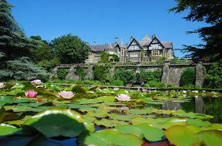
(near Tal-y-Cafn, in Conwy, Wales, UK) Nestied in the Snowdonian foothills of North Wales, Bodnant Garden was forged by the Victorian vision of an extraordinary man, then honed by his descendants -- and is still today cherished by visitors the world over. Established in 1874 by scientist, businessman, and politician Henry Pochin, he and his family filled the garden with plants collected by famous global explorers such as Ernest Wilson, George Forrest, and Harold Comber. Laid out in 1875 and painstakingly landscaped over 150 years, Bodnant is one of Wales’ most beautiful gardens. Lord Aberconway of the McLaren family (which once lived in the gracious late-18th-century abode [featured here] at the heart of Bodnant) bequeathed the lush 32-hectare (~79 acre) property to the National Trust in 1949. Formal Italianate terraces overlook the River Conwy and Snowdonia's Carneddau Mountains, and rectangular ponds creep down from the house into the orderly disorder of a pretty wooded valley and wild garden. Cared for by the National Trust since 1949, Bodnant is a garden of firsts -- home to the earliest and grandest laburnum arch built in 1880, to Britain’s earliest magnolias introduced from China in the late 1800s and to unique rhododendron hybrids which originated here from the 1920s. Today, Bodnant Garden is home to exotic plants from the Blue Poppy of the Himalayas to the Fire Bush of the Andes, as well as five National Collections -- of Magnolia, Embothrium, Eucryphia, Rhododendron forrestii and Bodnant Rhododendron Hybrids. It is also boasts Wales’ largest collection of UK Champion Trees, which provide their won year-round spectacle. In Spring, visitors enjoy swathes of daffodils, camellias, magnolias, and rhododendrons; the heady sight and scent of roses, lily ponds, herbaceous beds and buzzing wildflower meadows in Summer; a kaleidoscope of rich leaf color in Autumn; and sparkling, frosted landscapes in Winter.


In the city of Sicily, Italy

 “All of Sicily is a dimension of the imagination.” -- Leonardo Sciascia

===============================================================

(in Italy) Sicily, the largest island in the Mediterranean Sea, is an autonomous region of Italy that includes numerous smaller isles. It is separated from the mainland region of Calabria by the five kilometer (~3 mi.) Straits of Messina. Sicily is blessed with great art and along history; from Agrigento’s Valley of the Temples to Palermo’s Baroque churches, and a home at various times, to every great Mediterranean civilization. The island’s distinctive geological feature is Mount Etna, Europe’s tallest active volcano. Featured here is the town of Taormina in eastern Sicily, on a hill rising almost perpendicularly from the sea, at the foot of Monte Tauro between Messina and Catania. Founded in the 4th century BCE, Taormina enjoyed great prosperity under the Greek ruler Gelon II and later under the Romans, but fell into quiet obscurity after being conquered by the Normans in 1087. Its reincarnation as a tourist destination dates to the 18th century, when northern Europeans discovered it on the "Grand Tour." Among its fans was D.H. Lawrence, who lived here between 1920 and 1923. There are also remains of the Roman Odeon theater here, discovered during excavations in 1892, and of the so-called Naumachia (a reservoir). The famous Greek theater, rebuilt in Roman times, stands on the spur of Monte Tauro, affording a splendid view of Mt. Etna to the southwest and the mountains of Calabria across the sea to the north. The cathedral and the Corvaja, Santostefano, and Ciampoli palaces date from the medieval period. Volcanic Mount Etna and the Ionian Sea provide the cinema-worthy backdrop for Taormina, Sicily's legendary resort town. Twisting medieval streets and a 2nd-century Greek theater add to its romantic air, which inspired the writings of D.H. Lawrence (and Truman Capote). Take a cable car to the beach, or walk uphill behind the Church of St. Joseph for panoramic views.


Thursday, 21 October 2021

In the city of Rastatt, Baden-Württemberg, Germany

 Although uprisings in Germany during the late 1840s were suppressed by the forces of reaction, their ultimate goals were eventually realized. Baden had been the scene of the first of the 1848 uprisings in Germany, which helped to set the stage for the rise of a more modern, unified Germany, in 1871 .

=================================================================

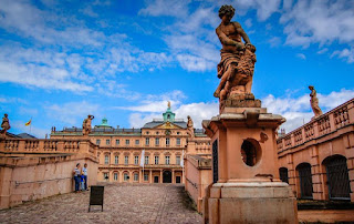
(in the German state of Baden-Württemberg) A city with a baroque core, Rastatt is found in the Upper Rhine Plain on the Murg River, six kilometers (~4 mi.) above its junction with the Rhine. An important place associated with the early-18th-century War of the Spanish Succession (the Treaty of Rastatt was signed here), as well as the Revolutions of 1848/1849 in the German states. Until the end of the 17th century, Rastatt held little influence, but after its destruction by the French in 1689, it was rebuilt on a larger scale by Louis William, margrave of Baden, the imperial general in the Habsburg-Ottoman War, known popularly as Türkenlouis. It then remained the residence of the margraves of Baden-Baden until 1771. It was the location of the First and Second Congress of Rastatt, the former giving rise to the Treaty of Rastatt. In the 1840s, Rastatt was surrounded by fortifications to form the fortress of Rastatt. For some 20 years prior to 1866, it was occupied by the troops of the German Confederation. The Baden revolution of 1849 began with a mutiny of soldiers at Rastatt in May of that year under Ludwik Mieroslawski and Gustav Struve, and ended here a few weeks later with the capture of the town by the Prussians. For years afterwards, Rastatt remained one of the strongest fortresses of the German empire, but its fortifications were dismantled in 1890. Between 1946 and 1954, about 20 major criminal proceedings (known as the Rastatt Trials) for crimes against foreign workers and prisoners in smaller camps in the National Socialist camp system in southwest Germany took place in front of the French Military Administration's Tribunal Général, along with more than 2,000 defendants. Today, Rastatt and its surrounding area -- in the vicinity of the Black Forest and the French border -- is home to a variety of historical buildings, including palaces and castles such as Schloss Rastatt and Schloss Favorite. Featured here is Schloss Rastatt, a historical structure in Rastatt. The palace and the garden were built between 1700 and 1707 by the Italian architect Domenico Egidio Rossi, as ordered by Margrave Louis William of Baden. During the Palatinate War of Succession (from 1736-1742), the residence of Margrave Louis William of Baden-Baden had been burned by French troops. A rebuild of the destroyed building would not have suited the representative needs of the court of Baden-Baden. Since he also needed a home for his wife Sibylle Auguste of Saxe-Lauenburg, whom he had married in 1690, the Margrave had a new residence built in place of the former hunting lodge. During this operation, the 1697 hunting lodge was demolished to leave space for the new palace.


In the town of Pays de Caux, in the Normandy region of northern France

 “A garden to walk in and immensity to dream in -- what more could he ask? A few flowers at his feet and above him the stars.”

― Victor Hugo, Les Misérables
===============================================================

(on the coast of the English Channel in the Pays de Caux, in the Normandy region of northern France) The Pays de Caux is an area in Normandy occupying the greater part of the French département of Seine Maritime. Tucked away on the Alabaster Coast, just 12 miles (~19 km) southwest of Dieppe, the lovely village of Veules-les-Roses is a cluster of half-timbered cottages and lots of ancient charm. The Veules, which flows through the village, is France’s shortest river. Its water is used in ponds for growing watercress, from which it finds its way to the sea through a gap in the high chalk cliffs that overlook a sand and pebble beach. One of the oldest villages in the Pays de Caux, Veules-les-Roses became a popular holiday resort in the 19th century, cherished by artists such as Victor Hugo. Today, a pleasant, laid-back atmosphere makes Veules-les-Roses quite a delightful seaside retreat, brimming with local restaurants specializing in fresh fish and oysters. Many of the houses at Veules-les-Roses are still maintained as they were when built several centuries ago. Many with thatched roofs, the old but well maintained houses, and their fascinating layout, make the village a memorable place to explore on foot. (There are several walking paths in the village. Most of them start at the beginning of the village and snake through the village.) Considered to be one of the oldest villages in the Pays de Caux, the seaside hamlet of Veules-les-Roses has been inhabited since the 4th century and is now highly regarded as one of Normandy’s prettiest places. The village is nestled on the banks of the Veules, which winds its way past historic thatched cottages and watermills down to the shore where the famous Veulaise oysters are harvested -- and a pretty little beach is flanked by dramatic cliffs.


In the city of Sarajevo, capital and cultural center of Bosnia and Herzegovina

 “It's a rare gift to understand that your life is wondrous, and that it won't last forever.” ―  Steven Galloway, author of The Cellist of Sarajevo

================================================================

(in the capital and cultural center of Bosnia and Herzegovina). The city of Sarajevo, found in the narrow valley of the Miljacka River at the foot of Mount Trebević, retains a strong Muslim character, having many mosques, wooden houses with ornate interiors, and the ancient Turkish marketplace (the Baščaršija). A late 16th-century clock tower is adjacent to the Begova Džamija -- the largest historical mosque in the country and one of the most representative Ottoman structures in the Balkans. Museums include the Mlada Bosna (“Young Bosnia”), an annex of the town museum; the Museum of the Revolution, chronicling the history of Bosnia and Herzegovina since 1878; and a Jewish museum. Sarajevo has a university that includes faculties in mining and technology, an academy of sciences, an art college, and several hospitals. The Kazandžviluk (coppersmith’s bazaar) is preserved in its original form. Although war took its toll here, during the 1992-1996 siege of Sarajevo, the lively, museum-rich city has been mostly reconstructed since then. Don't miss Bijambare caves, set in thick forests and amid lakes to the north of the city, or Bosna Springs, from which the country takes its name. Site of 1984's Winter Olympics, Sarajevo again offers spectacular skiing on Mount Bjelasnica Jahorina. Centuries-long rule by the Ottoman Empire has left its mark on this country at the heart of the Balkan region; whether it be in religion, architecture, cuisine or language. A melting pot of cultures and religions for centuries, Sarajevo has emerged from the dark years of the Bosnian war as a cosmopolitan, youthful, and modern European capital, with a unique personality. Cross the legendary Latin Bridge and stop for a bit at the point where Archduke Franz Ferdinand of Austro-Hungary was assassinated. Featured here is the Latin Bridge, named Principov most ("Princip's Bridge" in the Yugoslavian era), an Ottoman bridge over the Miljacka River in Sarajevo. The northern end of the bridge was the site of the assassination of Archduke Franz Ferdinand of Austria by Gavrilo Princip in 1914, which began the July Crisis that ultimately led to the outbreak of World War I. The bridge took its name from the neighborhood on the left bank of the Miljacka, where Sarajevo’s Catholics resided. From 1918 to 1993 the structure bore the name, Principov Most (bridge), after Gavrilo Princip, who was only a few meters from this bridge when he assassinated Archduke Franz Ferdinand (and his pregnant wife, Sofie). Of all the crossing points of the Miljacka River, this pale-stone bridge is the most famous. After the demise of Yugoslavia, Princip lost his public aura as a heroic revolutionary, and the bridge reverted to its original name. (This incident, known as the Sarajevo Assassination, led to the beginning of the First World War.)


In the city of Masstricht, Netherlands

 “Thus I am in Holland, the kingdom of things, great principality of objects. In Dutch, schoen means beautiful and at the same time clean, as if neatness was raised to the dignity of a virtue.” ― Zbigniew Herbert

==================================================================

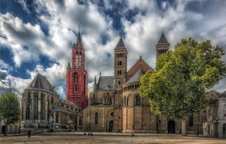
(in Holland, on the western coast of the Netherlands) Holland constitutes the flat, low-lying northwestern portion of the Netherlands. Touching Belgium on its west and quite close to Germany, Maastricht (featured here) is the capital of Limburg, Holland’s southernmost region. A city rich in history and culture, Maastricht boasts two great town squares: Vrijthof, with Sint-Servaas Church, Sint-Jan's Cathedral, and many cafes and restaurants; and Markt, home to the Town Hall and a popular vendor market. The city’s Old Town fortifications, are another big attraction. Maastricht is found along the Meuse (Maas) River at the junction of the Juliana, Liège-Maastricht, and Zuid-Willems canals. Now the main principal city in the southeastern area of the Netherlands, Maastricht was the site of the Roman settlement Trajectum ad Mosam (“Ford on the Meuse”) and later the seat of a bishop. from 382 to 721. The town was held by the dukes of Brabant after 1204, coming under the joint sovereignty of Brabant and the prince-bishops of Liège in 1284, and of Liège and the Dutch Estates-General in 1632. It was taken by the Spanish in 1579, by Prince Frederick Henry of Orange in 1632, and by the French in 1673, 1748, and 1794, but it resisted the Belgians in 1830–32. Portions of its old fortifications have survived. Attacked on the first day of the German invasion of the Low Countries in 1940, Maastricht was the first Dutch town to be liberated, in 1944. Following a 1991 meeting of the European Communities that was held in Maastricht, an accord (known as the Maastricht Treaty) was signed calling for the establishment of a European Union, with common policies on economics, foreign affairs, security, and immigration. Maastricht’s landmarks include the St. Servatius Bridge over the Meuse; the Dinghuis, or former courthouse; and the Town Hall. The cathedral, dedicated to St. Servatius, was founded by Bishop Monulphus in the 6th century; it is the oldest church in The Netherlands. The Protestant Church of St. John, with its 75-meter tower, originally served as its parish church. The Church of Our Lady has remnants of 10th-century crypts. There are many other medieval churches, as well as fine houses in regional Renaissance and French styles. Maastricht is also the site of the University of Limburg, a music conservatory, a symphony orchestra, art academies, and several museums. To the south are the sandstone (marl) quarries of St. Pietersberg, comprising more than 200 miles (322 km) of underground passages worked from Roman times to the 19th century. They served to hide peasants and cattle during the wars with Spain and art treasures and refugees during World War II.


In the capital city of Tallin, in the Republic of Estonia

 “In every port in the world, at least two Estonians can be found.” -- Ernest Hemingway, To Have and Have Not

===================================================================

(in the Republic of Estonia) The northernmost of the three Baltic states. Estonia’s area includes some 1,500 islands and islets; the two largest islands, Saaremaa and Hiiumaa, are off mainland Estonia’s west coast. Estonia has been dominated by foreign powers through much of its history. In 1940 it was incorporated into the U.S.S.R. and remained a Soviet republic until 1991, when (along with the other Baltic states) it declared its independence. UN-membership followed shortly thereafter, and Estonia soon transformed its government into a parliamentary democracy, while reorienting its economy toward market capitalism. It sought integration with greater Europe and in 2004 joined the North Atlantic Treaty Organization (NATO) and the European Union (EU). With a newfound confidence, singular Estonia has abandoned Soviet control and leaped into the arms of Europe. The attraction is mutual. Europe has embraced the charms of Tallinn (featured here) and its UNESCO-protected Old Town. Today, Tallinn (the capital of Estonia) s now one of Europe's most captivating cities. The country's sparsely populated countryside and extensive swathes of forest provide spiritual sustenance for nature-lovers from across the continent. The city of Tallinn is found on Tallinn Bay, part of the Gulf of Finland. A fortified settlement existed here from the late 1st millennium BCE until the 10th–11th century CE, and a town occupied this site in the 12th century, though it was soon captured by the Danes (in 1219), who built a new fortress on Toompea hill. Trade flourished, especially after Tallinn joined the Hanseatic League in the 13th century. In 1346 it was sold to the Teutonic Knights, and on the dissolution of their order in 1561 it passed to Sweden. Peter I (the Great) captured Tallinn in 1710, and it remained a Russian city until it became the capital of independent Estonia from 1918 to 1940, after which it was annexed to the USSR from 1940 to 1991. The city was occupied by German forces from 1941 to 1944 and was severely damaged. After Estonia declared independence in 1991, Tallinn became the capital of the newly independent state. Many relics of Tallinn’s long history survive (or have been restored), especially on Toompea hill and in the old, walled Lower Town. They include the 13th-century Toom Church, the Gothic Oleviste and Niguliste churches, the Great Guildhall of 1410, the 14th-century Rathus, and much of the old castle. Today, Tallinn is a major commercial and fishing port and industrial center. Machine building and shipbuilding head a range of engineering industries, and many consumer goods are produced here. The cultural center of Estonia, Tallinn has an academy of sciences; polytechnic, fine-arts, and teacher-training institutes; a music conservatory; and, several theatres and museums.


In the historical town of Zadar, in southwestern Croatia

 "The biggest challenge to life in Croatia is hope…. It’s as if there is some vague force of darkness trying to eclipse even the thinnest rays of optimism…. And while hope in Croatia is hard, its absence is offset by the strong personal relationships that tie individuals to the broader society. In Croatia it can be hopeless, but you never feel alone." -- Cody McClain Brown

=================================================================

(in the oldest continuously inhabited Croatian city) Zadar, a historical town in southwestern Croatia (and the former capital of Dalmatia), is found on the end of a low-lying peninsula that is separated by the Zadar Channel from the islands of Ugljan and Pašman. The inlet between the peninsula and the mainland creates a natural deep water harbor. Its Old Town on the peninsula dates from the 9th century BCE, when it was a Liburnian settlement called Jadera. The town became Roman in the 1st century BCE. Spared during the Avar and Slavic invasions of Dalmatia (5th–6th century CE), it remained a thriving commercial, cultural, and artistic center of Byzantine Dalmatia. Between 1045 and 1358 the town was intermittently at war with Venice, and in 1409 it was sold to Venice. It withstood a Turkish attack in 1571, and in the succeeding period Zadar became the most heavily fortified town on the Adriatic Sea, until its fortifications were partly demolished in the late 19th century. The town was an Austrian possession from 1797 to 1920, except for a brief French interregnum between 1808 and 1813. By the Treaty of Rapallo (in 1920), Zadar became Italian, thereby losing further ground to Split as the chief town of Dalmatia. During the course of World War II, Allied bombing destroyed 75 percent of Zadar’s buildings and damaged the port facilities. Liberated in 1944, it became part of Yugoslavia. Most new construction has taken place on the mainland. The Zadar Riviera is a developing resort center for water sports. The town has excellent road, rail, air, and ferry connections with the rest of the Balkan region and with Italy. Old Zadar is especially noted for the many fine churches that survived the air raids during World War II, as did the Roman forum and several of the old, narrow cobbled streets. St. Donat’s remarkable circular church (included in this photo) dates from the 9th century; the 11th-century St. Mary’s Church has one of the most important church treasuries in Croatia; and the Romanesque Church of St. Krševan was consecrated in 1175. There are also the 13th-century Cathedral of St. Stošija (Anastasia), the largest and finest Romanesque church in Dalmatia, and the 13th-century Franciscan church and monastery. Zadar also has an archaeological museum, the state archives, a theater, and a branch of the University of Zagreb. With its Roman ruins, art installations, and white-sand beach, Zadar is now one of the most unique resorts along Croatia’s Dalmatian coast, where in-the-know travelers come to feast on seafood, watch dreamy sunsets, and sip cocktails at oceanside bars.


In the city of Lugo, in the autonomous community of Galicia, northwestern Spain

 “There is of course a deep spiritual need, which the pilgrimage seems to satisfy, particularly for those hardy enough to tackle the journey on foot.” ― Edwin Mullins, The Pilgrimage to Santiago

===================================================================

(in northwestern Spain) The city of Lugo, capital of Lugo province in the autonomous community of Galicia, northwestern Spain, is found on the Miño River, southeast of A Coruña. Lugo originated as the Roman Lucus Augusti, and its Roman walls, which were added to UNESCO’s World Heritage List in 2000, remain a public walkway. The city was occupied by Suebi (Suevi), Moors, and Normans and was recaptured by King Alfonso III of Asturias and Leon in the 10th century. Notable landmarks include the Gothic Church of San Francisco, the cloister of which is a national monument, and the 12th-century Romanesque cathedral, with Gothic, Baroque, and Neoclassical additions. Lugo is the only city in the world to be surrounded by completely intact Roman walls, which reach a height of 10 to 15 meters along a 2,117-meter circuit ringed with dozens of towers. The walk along the top is continuous round the circuit, and features ten gates. Like Santiago de Compostela, Lugo has been a pilgrimage destination since the Middle Ages. The "Camino Primitivo," which forms a part of the Camino de Santiago (St. James Way), starts in Oviedo, then leads to Lugo and south to Santiago de Compostela. This route has become very popular in recent years because it is less crowded than other alternatives. Conquered from the Celts in the 13th century BCE by the Romans, Lugo became the most crucial town in Hispania Tarraconensis, not least because of its rich gold mines, which were quite active in Roman times. During their many centuries of rule, the Romans left famous monuments, among them the bridge over the Minho. Repaired and restored many times, the six elegant arches still cross the river and are particularly attractive when illuminated from below at night. Not far from the wall and the city center, visitors can enjoy Lugo’s largest park, named after Rosalia de Castro, Galicia’s most famous poetess. Her favorite flower was the camellia, which is also the national flower of Galicia. The park covers 61 acres (~25 hectares), with a lovely pond in the middle. Walkways, lookouts over the river, a play area for children, and plenty of flowers and trees (like redwood conifers, magnolias, and camellias) make for a quiet respite from exploring the city. For a glimpse of the luxury and splendor in which wealthy Romans lived, head to the center of the Old Town and visit the underground remains of an ancient villa, known as the Domus Oceani, or the House of Mosaics. (Colorful mosaics that cover floor and walls remain fresh and intact.)


In the region of Provence, southeastern France

 Lavender was used as a bath additive in regions like Persia, Rome, and Ancient Greece. These cultures believed that lavender helped to purify the body and mind. Today, lavender flowers symbolize spirituality, purity, silence, love, grace, serenity, and calmness.

=================================================================

(in southeastern France) Provence is a geographical region and historical province of southeastern France, which extends from the left bank of the lower Rhône River to the Italian border; it is bounded by the Mediterranean Sea to the south. It largely corresponds with the modern administrative region of Provence-Alpes-Côte d'Azur and includes the departments of Var, Bouches-du-Rhône, Alpes-de-Haute-Provence, as well as parts of Alpes-Maritimes and Vaucluse. The largest city of the region is Marseille. The Romans made this region their first province beyond the Alps and called it Provincia Romana, which evolved into the present name. Until 1481 it was ruled by the Counts of Provence from their capital in Aix-en-Provence, then became a province of the Kings of France. While it has been part of France for more than five hundred years, it still retains a distinct cultural and linguistic identity, particularly in the interior of the region. Lavender fields in France are found in Provence, on the Valensole Plateau that stretches over an area of 800 square kilometers (~309 square miles) covered with beautiful flowers. The Plateau is situated in the south of the Alpes-de-Haute-Provence and near the Verdon Gorges – France’s "Grand Canyon." There are several charming villages that you can visit on a day trip while you are visiting lavender fields. If you are staying in Aix-en-Provence, you will find it to be a great base for exploring much of Provence, its Lavender Fields, and the Gorges du Verdon. Provence seems to be nearly everyone's favorite part of France. The locals are friendly, the summer weather is great, the wine is fine, and a pastis before dinner is delightful as you sit in the shade and savor a bit of anise-flavored liquor. (With landscapes often exceeding the expectations of travelers, the rural "good life" can hardly get better than this.)


In the island of Cephallenia, also called Kefalonia, west of the Gulf of Patraïkós, Greece

 “Life is largely a matter of expectation. ”― Homer

===============================================================

The island of Cephallenia, also called Kefallonia, is the largest of the Ionian Islands, west of the Gulf of Patraïkós. With the island of Ithaca and smaller nearby islands, it forms the department of Kefallinía in modern Greece. The island, with an area of 302 square miles (781 square km), is mountainous, and Mount Aínos (ancient Mount Aenos;) is often snowcapped for months. In the west a gulf penetrates the island from the south; on its east side is the capital and port of Argostólion. Once an important Mycenaean center, in the Peloponnesian War it sided with Athens and later became a member of the Aetolian League. It surrendered to Rome in 189 BCE but later revolted and was subdued. During the Middle Ages it was captured by the Norman adventurer Robert Guiscard, who died there during a revolt in 1085. It then was ruled by various Neapolitan and Venetian families until it fell to the Turks at the end if the 15th century), only to revert again to Venetian rule. In 1797, France briefly possessed it, and in 1809 it was taken by the British, who established a protectorate over the Ionian Islands by the terms of the Treaty of Paris (in 1815). The islands were ceded to Greece in 1864. Perhaps the most enticing of all the Ionian islands, magical Kefallonia is a place where it's easy to lose track of time, amid air thick with oleander and the sound of goat bells. Perhaps the most varied of the Ionian islands, there is space to breathe here, and its convoluted coastline conceals lots of captivating coves and beach-lined bays lapped by gin-clear waters teeming with colorful fish. Despite the devastating earthquake of 1953 that razed much of the island's historic Venetian architecture, ravishing harbor-front villages such as Fiskardo and Assos (depicted here) still project Italianate good-looks, while the lush and mountainous interior, dotted with wild meadows, Mediterranean oak forests, and vineyards, invites endless exploration. Not far from the beautiful Myrtos bay, the charming village of Assos is a delightful place on Kefalonia island, in an area is green with many Cyprus trees. Upon entering the village visitors immediately reach a small square with old restyled houses, some romantic traditional Greek restaurants and a pier built for private boats and local fishermen. Though the local beach is small, the sea water here is known for its an amazing blue color. One side of the village is a peninsula-like extension connecting Assos village with its old castle -- a 15th-century fortress built to protect this part of Kefalonia from the pirates of the sea. The charming, bloom-filled village of Assos on Kefalonia is one of the most compelling reasons to visit the Greek Islands. This village at the bottom of a hill, is surrounded on three sides by the deep-blue Mediterranean. Spend some time on its pebbled beach before enjoying local food in one of the great restaurants lining the marina.


In the historical town of Kaysersberg, in Alsace, northeastern France

 "Nothing more excellent or valuable than wine was ever granted by the gods to man." -- Plato

================================================================

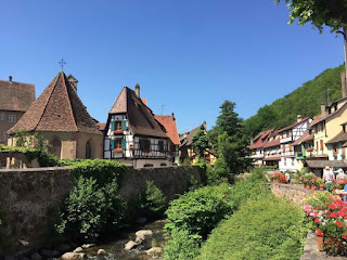
(in northeastern France) Kaysersberg, "One Of The Most Beautiful Villages In France," is found in the Alsace region of France, the eastern part of the country that lies at the foot of the Vosges -- bordering both Germany and Switzerland, one of the loveliest regions of France. Known for its Route du Vin, the most famous wine route in France, a marked series of roads that meander through pretty little wine villages with colorful half-timbered buildings and castles perched on hilltops. The route is just over 100 miles (160 km) long,, starting just west of Strasbourg, with the Rhine River that borders Germany to the east and the Vosges mountains to the west, then heads south towards Colmar and beyond to Mulhouse. Just 10 km (~6 mi.) northwest of Colmar, Kaysersberg is quite a heart-stopper with its backdrop of gently sloping vines, hilltop castle, and old fortified bridge spanning the rushing Weiss River. You will also find other historical monuments as you explore Kaysersberg, many dating from the 15th century, such as the towers, bridge and ramparts, and the 16th century Town Hall, each adding their own bit to the charm of the town. From many parts of the town you can see the ruins of the Chateau de Kaysersberg (the castle) poised high on the hill above it. An important route passes through the valley here (the Col du Bonhomme) that has been defended since Roman times, with the castle being built in the 13th century. In the centuries since, this remained a prosperous town (apart from the years around the time of the Thirty Years War).


In the city of Ediburgh, capital of Scotland

 Edinburgh is one of the most popular destinations in Europe. ======================================================================= (the ...