“Thus I am in Holland, the kingdom of things, great principality of objects. In Dutch, schoen means beautiful and at the same time clean, as if neatness was raised to the dignity of a virtue.” ― Zbigniew Herbert
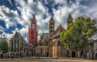
==================================================================(in Holland, on the western coast of the Netherlands) Holland constitutes the flat, low-lying northwestern portion of the Netherlands. Touching Belgium on its west and quite close to Germany, Maastricht (featured here) is the capital of Limburg, Holland’s southernmost region. A city rich in history and culture, Maastricht boasts two great town squares: Vrijthof, with Sint-Servaas Church, Sint-Jan's Cathedral, and many cafes and restaurants; and Markt, home to the Town Hall and a popular vendor market. The city’s Old Town fortifications, are another big attraction. Maastricht is found along the Meuse (Maas) River at the junction of the Juliana, Liège-Maastricht, and Zuid-Willems canals. Now the main principal city in the southeastern area of the Netherlands, Maastricht was the site of the Roman settlement Trajectum ad Mosam (“Ford on the Meuse”) and later the seat of a bishop. from 382 to 721. The town was held by the dukes of Brabant after 1204, coming under the joint sovereignty of Brabant and the prince-bishops of Liège in 1284, and of Liège and the Dutch Estates-General in 1632. It was taken by the Spanish in 1579, by Prince Frederick Henry of Orange in 1632, and by the French in 1673, 1748, and 1794, but it resisted the Belgians in 1830–32. Portions of its old fortifications have survived. Attacked on the first day of the German invasion of the Low Countries in 1940, Maastricht was the first Dutch town to be liberated, in 1944. Following a 1991 meeting of the European Communities that was held in Maastricht, an accord (known as the Maastricht Treaty) was signed calling for the establishment of a European Union, with common policies on economics, foreign affairs, security, and immigration. Maastricht’s landmarks include the St. Servatius Bridge over the Meuse; the Dinghuis, or former courthouse; and the Town Hall. The cathedral, dedicated to St. Servatius, was founded by Bishop Monulphus in the 6th century; it is the oldest church in The Netherlands. The Protestant Church of St. John, with its 75-meter tower, originally served as its parish church. The Church of Our Lady has remnants of 10th-century crypts. There are many other medieval churches, as well as fine houses in regional Renaissance and French styles. Maastricht is also the site of the University of Limburg, a music conservatory, a symphony orchestra, art academies, and several museums. To the south are the sandstone (marl) quarries of St. Pietersberg, comprising more than 200 miles (322 km) of underground passages worked from Roman times to the 19th century. They served to hide peasants and cattle during the wars with Spain and art treasures and refugees during World War II.