Monday, 17 June 2024

In the city of Mostar, in southern Bosnia and Herzegovina

 "If we are to find our way across troubled waters, we are better served by the company of those who have built bridges, who have moved beyond despair and inertia."

-- Marilyn Ferguson
=====================================================================
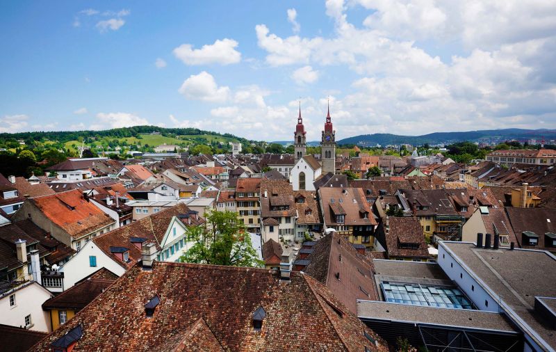
(in the south of Bosnia and Herzegovina) In the region of Herzegovina, Mostar is one of the Balkan’s most interesting towns. Though small, wander its many bridges, sample regional wine, and watch the locals jump off the famous Old Bridge into the river.

+ Mostar, the chief city (and, historically, the capital of Herzegovina), is found in a mountainous country along the Neretva River and lies on the Sarajevo-Ploče rail line. First mentioned in 1452, Mostar became a Turkish garrison town in the 16th century. In 1566 the Turks replaced the town’s wooden suspension bridge over the Neretva with a stone arch one, from which came the name Mostar (from Serbo-Croatian most, “bridge”). This stone bridge had a single arch 90 feet (27 meters) wide and was a masterpiece of Ottoman engineering. In November 1993, during the Bosnian civil war, the bridge was destroyed by artillery fire from Bosnian Croat forces. A major rebuilding project was undertaken to restore the bridge and nearby buildings that had also been damaged; the bridge reopened in 2004. (The bridge and the surrounding area were added to UNESCO’s World Heritage list in 2005.)

+ Mostar served as a center for crafts and trade, and its reconstructed coppersmith’s bazaar is a tourist attraction. While under Austrian rule (1878–1918), Mostar became a center for Serbian scholars and poets. Počitelj, south of Mostar, is famous for its Muslim architecture with a mosque, madrasah (school), and Turkish houses.

+ Mostar was named after the bridge keepers (mostari) who guarded the Stari Most (Old Bridge) over the Neretva during the Ottoman era. The Old Bridge, a UNESCO World Heritage Site, commissioned in the 16th century, is one of the country's most visited landmarks.

+ Austria-Hungary took control over Bosnia and Herzegovina in 1878 and ruled the region until the aftermath of World War I in 1918, when it became part of the State of Slovenes, Croats and Serbs (and then Yugoslavia).

+ After Bosnia and Herzegovina declared independence from Yugoslavia in April 1992, the town was besieged by the Yugoslav People's Army (JNA), following clashes between the JNA and Croat forces.

+ On 7 June the Croatian Army launched an offensive code-named Operation Jackal, the objective of which was to relieve Mostar and break the JNA siege of Dubrovnik. The offensive was supported by the HVO, which attacked the Army of Republika Srpska (VRS) positions around Mostar. By 12 June the HVO secured the western part of the city and by 21 June the VRS was completely pushed out from the eastern part.

+ In early 1993 the Croat–Bosniak War escalated and by mid-April 1993 Mostar had become a divided city with the western part dominated by HVO forces and the eastern part controlled by the Army of the Republic of Bosnia and Herzegovina (ARBiH).


Sunday, 2 June 2024

In the city of Salzburg, capital of Salzburg (a federal state), west-central Austria

 Wolfgang Amadeus Mozart's birthplace, Salzburg's story-book Altstadt (Old Town), burrowed below steep hills, looks much as it did when Mozart lived here some 250 years ago.

====================================================================
(in west-central Austria) The city of Salzburg, capital of Salzburg (a federal state) is found in a level basin on both sides of the Salzach River near the northern foothills of the Alps and the Bavarian (German) border. The historic center of the city was added to the UNESCO World Heritage List in 1996.

+ Salzburg is close to Germany's southwest border and is well connected via train or bus to nearby cities like Prague in the Czech Republic and Munich in Germany. It also has many claims to fame, from centuries-old monuments to film and music. Gazing over the city is the Fortress Hohensalzburg castle, dating back to the 11th century. Archbishops of the era wanted to show off their power and protect themselves from rivals. (Tours run every day in the summer and offer expansive mountain views and views of the city below, but Christmas tours on Advent weekends in December make for an even more fairytale-like experience.)

+ A unique combination of scenic Alpine landscape and architectural beauty has led to Salzburg’s reputation as one of the world’s most beautiful cities. Its chief glories are the episcopal buildings and the burghers’ houses, displaying an Italian Renaissance and Baroque influence that earned Salzburg the designation of the “German Rome.” In the center of the “older town,” on the left bank of the Salzach, is the Residenzplatz with the archbishop’s residence, a gallery of 16th–19th century European paintings, and a large Baroque fountain. Opposite is the Residenz Neugebäude (Residence New Building. The cathedral, or Dom, was constructed on the site of a previous Romanesque cathedral and an earlier, 8th-century basilica.

+ Near the Mönchsberg (Monks’ Hill), a ridge overlooking the Old Town, is the Benedictine Abbey of St. Peter; most of its buildings date from the 17th and 18th centuries, and its church was remodeled in the Rococo style. North of the abbey is the Franciscan Church, with a Romanesque nave), a 15th-century Gothic choir, and Baroque chapels. Crowning Monks’ Hill is the great fortress of Hohensalzburg (completed in 1681), which served as the archbishops’ residence during the wars of the 15th and 16th centuries. Also on the hill are St. George’s Churchand the Nonnberg Nunnery.

+ Among landmarks in the “newer town” (on the right bank of the Salzach) are St. Sebastian’s Church, the Holy Trinity Church, and the Mozarteum (comprising a music academy, concert halls, and Mozart archives). On the city outskirts are the Capuchin Friar and the castles of Leopoldskron and Hellbrunn. The university was reestablished in 1962. The Kollegien, or University Church is a Baroque masterpiece by Fischer von Erlach.

+ Salzburg suffered relatively little damage during World War II and was the headquarters of the U.S. military forces in Austria from 1945 to 1956.


In the city of Hamburg, the second-largest city in Germany, after Berlin

 Welcome to one of the coolest cities on earth:

====================================================================
(in the second-largest city in Germany, after Berlin) Hamburg, a city-state on the Elbe River is the country’s largest port and commercial center (and the second smallest of the 16 states of Germany. The characteristic individuality of Hamburg has been maintained by its people so that the city’s culture has retained its uniqueness. The city has more consulates than any other city in the world (except New York City). Shipping and trade have been Hamburg’s lifeblood for centuries. These are among the attractions that have contributed to a growing tourist industry. (Although it was badly damaged during World War II, Hamburg has succeeded in maintaining a sense of old-world grace.

+ The nucleus of the city is the Altstadt (Old Town), the former medieval settlement. Within this core there are few great buildings to remind the visitor of the city’s thousand-year history, apart from the five principal churches. Fire has destroyed almost all the older residences and warehouses. Yet, there are a few survivals of older buildings, and the layout of the old city center can still be detected in some of the street names and in the canals.

+ The Poggenmühlenbrücke (shown here) is a bridge along one of the main canals and one of Hamburg's most photogenic spots. The Water Castle sits in the middle of the water with two bridges on either side. You can see fishermen most days of the week, hoping to catch eels and carp.

+ Although it was badly damaged during World War II, Hamburg has maintained a sense of old-world grace. At the heart of Hamburg is a lake, formed by the damming of the Alster and divided by the Lombardsbrücke into the Inner Alster and the Outer Alster.

+ In the period of German partition, Hamburg handled more than half of West Germany’s foreign trade. Since 1960, Hamburg has become the site of first-class trade fairs. Many of the fairs and conventions are held at the Ernst-Merck-Halle exhibition grounds, located south of the Planten un Blomen park. Harbor and city are well served by the German railway network, and the city has a good system of buses and underground trains. To relieve the central city from long-distance traffic, a tunnel was built (opened in 1977) under the Elbe as a part of the Stockholm-Lisbon highway.

+ Hamburg entered the 20th century determined to strengthen its position as “Germany’s gateway to the world.” (After the war the victorious Allies demanded nearly all of Hamburg’s ships by way of reparation from Germany.) The prospect of expansion was shattered by the outbreak, in 1939, of World War II. When the war ended in 1945, only the most strenuous efforts could supply the elementary needs for Hamburg’s survival. Though  reconstruction proceeded, nightclubs on the Reeperbahn would became proving grounds for British rock and roll bands (most notably the Beatles).

+ With the unification of Germany in 1990 the city underwent continuing modernization.


In the port city of Tórshavn; the capital of the Faroe Islands, Denmark

 Tucked between Iceland and Norway in the North Atlantic Ocean, this self-governed group of 18 volcanic islands is fast becoming a favorite Nordic destination.

====================================================================
(in the North Atlantic between Iceland and the Shetland Islands) The Faroe Islands are an archipelago in the North Atlantic Ocean and an autonomous territory of the Kingdom of Denmark. Located 320 km (200 mi.) north-northwest of the United Kingdom, the islands have a total area of about 1,400 square km (540 sq. mi.) with a population of 54,676 as of August 2023. The terrain is rugged, and the subpolar oceanic climate is windy, wet, cloudy, and cool. There are 17 inhabited islands and many islets and reefs. The main islands are Streymoy, Eysturoy, Vágar, Suduroy, Sandoy, Bordoy, and Svínoy.

+ With rolling green hills, dramatic cliff faces, and attraqctive coastal towns, there is something for everyone to enjoy here.

+ Music lovers may already recognize this region for its festival scene -- it typically hosts five live music festivals throughout the year -- but adventurers are also starting to catch wind of the archipelago's steep cliffs, hiking trails, waterfalls, and rocky coastlines.

+ These islands are high and rugged with perpendicular cliffs, the highest at Mount Slaettara on Eystur Island, and flat summits separated by narrow ravines. The climate is oceanic and mild, with little variation in temperature and frequent fog and rain. The warm North Atlantic Current keeps the harbors free of ice. Natural vegetation is moss, grass, and mountain bog. The islands are naturally treeless because of the cool summers, strong westerly winds, and frequent gales. There are no toads, reptiles, or indigenous land mammals; hares, rats, and mice came on ships. Seabirds are numerous and were in earlier times economically important.

+ The Faroese are of Scandinavian origin; many are descendants of Norwegian Vikings who colonized the islands about 800 CE. About a fourth of the population lives in Tórshavn, the remainder live in small settlements, almost all of which are on the coasts. The islands' name first appeared as Faereyiar (ca. 1225), meaning “Sheep Islands.” First settled by Irish monks (ca. 700), the islands were colonized by the Vikings (ca. 800) and were Christianized by the king of Norway (ca. 1000). The Faroes became a Norwegian province in 1035 and passed to Denmark with the rest of Norway in 1380. Separated from Norway administratively in 1709, they were attached to the diocese of Zealand and became a Danish royal trade monopoly. During World War II Great Britain controlled the Faroes while the Germans occupied Denmark, a situation that strengthened demands for home rule. In 1948 the islands were granted self-government under the authority of Denmark The University of the Faroe Islands in Tórshavn was founded in 1965.

+ Featured here is Tórshavn; the port and capital of the Faroe Islands, it is located in the southern part on the east coast of Streymoy.


In the port city of Bastia, in the island of Corsica in the Mediterranean Sea, south east of France

 "Victory belongs to the most persevering."

-- Napoleon Bonaparte
=====================================================================
(on Corsica). The port city of Bastia (shown here) opens its arms to weary travelers disembarking from a long ferry trip. For a truly charming Corsican experience, catch a train through the mountains to the beach, passing by rustic villages and grazing cows along the way.
+ Jutting from the foaming Mediterranean like an impregnable fortress, Corsica resembles a miniature continent, with astounding geographical diversity. Within half an hour's drive, the landscape ranges from glittering bays, vibrant coastal cities, and fabulous beaches to sawtooth mountain ridges, verdant valleys, dense forests, and time-forgotten hilltop villages.

+ Compared to the Mediterranean islands that belong to Spain and Greece, Corsica is among the larger islands in the Mediterranean Sea and is located north of Italy's Sardinia. Despite its distance from Paris, Corsica has significantly impacted France's national and international affairs because French emperor Napoleon Bonaparte was born in Corsica's coastal city, Ajaccio, in 1769. Ajaccio is quite intriguing for history buffs as visitors to the city can see his childhood home, the massive Palais Fesch art museum. It features paintings from the personal collection of Bonaparte's uncle, busts of the family, and a statue of Bonaparte at Place d'Austerlitz.

+ The island of Corsica, is one of the 18 regions of France. It is the fourth-largest island in the Mediterranean and lies southeast of the French mainland, west of the Italian Peninsula and immediately north of the Italian island of Sardinia, the nearest land mass. (A single chain of mountains makes up two-thirds of the island) Bastia and Ajaccio, on the coast, are the largest towns and home to about half of the island’s population. In the early 21st century some four-fifths of Corsica’s population was urban. In northern Corsica the Balagne (once called the “Garden of Corsica”) is also densely populated. The regional capital is Ajaccio. Although the region is divided into two administrative departments, Haute-Corse and Corse-du-Sud, their respective regional and departmental territorial collectivities were merged on 1 January 2018 to form the single territorial collectivity of Corsica.

+ Corsica was ruled by the Republic of Genoa from 1284 to 1755, when it seceded to become a self-proclaimed, Italian-speaking Republic. In 1768, Genoa officially ceded it to Louis XV of France as part of a pledge for the debts incurred after enlisting French military help in suppressing the Corsican revolt; as a result, France annexed the island in 1769. The future Emperor of the French, Napoleon Bonaparte, was a native Corsican, born that same year in Ajaccio: his ancestral home, Maison Bonaparte, is now a visitor attraction and museum. Because of Corsica's historical ties to Tuscany, the island has retained many Italian cultural elements, and many Corsican surnames are rooted in the Italian peninsula.


In the city of Winterthur, in the canton of Zürich in northern Switzerland

 Winterthur is a city of contrasts, where the industrial past meets the artistic present. Located just a short train ride from Zurich, Winterthur offers a rich variety of attractions for culture lovers, nature enthusiasts, and history buffs.

====================================================================
(in the canton of Zürich in northern Switzerland) Winterthur, with over 110,000 residents, is the country's sixth-largest city by population. Located about 20 kilometers (12 mi.) northeast of Zürich, Winterthur's official language is German, though the main spoken language is the local variant of the Alemannic Swiss German dialect, Zürich German. (Winterthur is usually abbreviated as Winti in the local dialect and by its inhabitants.)

+ One can explore the largest pedestrian zone in Switzerland here, where you can admire the medieval architecture and browse the charming shops and cafes. You can also visit some of the many museums in Winterthur, such as the Oskar Reinhart Museum am Römerholz, which displays masterpieces of modern art, the Technorama, which invites you to experiment with science and technology, or the Fotostiftung Schweiz, which showcases Swiss and European photography.

+ Winterthur is found in a wooded basin east of the Töss River, northeast of Zürich ( the largest city in Switzerland). (The Roman settlement of Vitodurum was on the site of the city’s northeastern suburb of Ober-Winterthur.) Winterthur was founded about 1175 by the counts of Kyburg, who granted it a charter with extensive privileges. It was inherited in 1264 by the Habsburgs, who sold it to the city of Zürich in 1467. Notable landmarks include the Town Church of St. Laurenz), the Town Hall, and the Assembly Hall. Notable among the advanced schools is the Technikum, Switzerland’s largest school of technology. The city’s picture gallery Collection Oskar, Reinhart am Römerholz (and its symphony orchestra) are well known.

+ Vitudurum was a vicus in what is now Oberwinterthur during the Roman era. It was fortified into a castrum at the end of the third century. The counts of Winterthur, a cadet branch of the family of the counts of Bregenz, built Kyburg castle in the 10 century. Winterthur as a city was founded by Hartmann III of Dillingen in 1180. From 1180 to 1263, Winterthur was ruled by the cadet line of the House of Kyburg. When the counts of Kyburg xxbecame extinct in the male line in 1263, Winterthur passed to the House of Habsburg, who granted city rights to Winterthur in the same year. From 1415 until 1442 Winterthur was subject only to the Holy Roman Emperor). In the Old Zürich War they lost this freedom and came back under the control of the Austrian Habsburgs. In 1467, the Habsburgs sold Winterthur to the city of Zürich. This ended in 1798, when Napoleonic troops took the town. On 27 May 1799, it was the site of the Battle of Winterthur between elements of the French Army of the Danube and elements of the Habsburg army, during the War of the Second Coalition, in the French Revolutionary Wars.


Friday, 31 May 2024

In the Dalmatian coastline, one of the four historical regions of Croatia

 Always buzzing and exuberant, Split (Croatia’s second-largest city) has just the right balance of  tradition and modernity -- the perfect place to see Dalmatian life as it is actually lived.

====================================================================
(in Dalmatia, on the Adriatic Sea.) Split is a popular tourist destinaton (with a dramatic coastline and turquoise blue waters. The city was founded as the Greek colony of Aspálathos in the 3rd or 2nd century BCE and became a prominent settlement around 650 CE. One of the world's most impressive Roman monuments, Diocletian's Palace was built as a military fortress and imperial residence. For breathtaking views of Split and its surrounding islands, visitors will want to take a trip to Marjan Forest Park. (An excursion through the forest will bring hikers to Bene Beach.) Located on a secluded cove of Marjan Forest Park, that charming beach offers a welcome respite after a busy day of exploring.

+ Due to its many former rulers (Roman, Austrian, and Yugoslav, to name a few), Split is a European city unlike any other. What you get is a one-of-a-kind mix of architecture and history on every cobblestoned corner: ancient ruins, open-air flea markets, and centuries-old cathedrals. A city seemingly frozen in time, it is home to pretty beaches and tranquil turquoise waters, on the Adriatic coast. The Riva, known as Split’s living room, is the city’s seaside promenade and a popular place to have an espresso and people-watch.

+ One of the world's most impressive Roman monuments, Diocletian's Palace is a UNESCO World Heritage site. Built as a military fortress and imperial residence, its labyrinth of streets buzzes with people, bars, shops, and restaurants. For breathtaking views of the city and surrounding islands, take a trip to Marjan Forest Park. Located on the western fringes of the city, the nature reserve has walking trails, scenic lookouts, and even medieval chapels.

+ A major commercial and transportation center, this city is best known for the ruins of the Palace of Diocletian. (Collectively with the historic royal residences, fortifications, and churches in the city, the palace was designated a UNESCO World Heritage site in 1979.)

+ Split also has a university and an oceanographic institute. Museums include the Meštrović Gallery, the Archaeological Museum, the Museum of Croatian Archaeological Monuments, the City Museum, the Art Gallery, and the Ethnographic Museum, which is housed in the Venetian Gothic town hall. The Croatian National Theatrewas gutted by fire in 1971 but reconstructed by 1979. The belfry of Our Lady of the Belfry church is the oldest in Dalmatia.

The city’s harbor and port, combined with its central position on the Adriatic coast and its good rail and road connections to the northern parts of the country, have made it important commercially. There is a large shipyard, and plastics, chemicals, aluminum, and cement are produced. Several island ferries depart from Split, and the city has an international airport.


A Journey Through the Soul of Switzerland: Ten Unforgettable Experiences

  A Journey Through the Soul of Switzerland: Ten Unforgettable Experiences.   Switzerland is more than a destination; it is a feeling....